Forecast Meridien Marinas Airlie Beach Race Week day 6
by Ken Batt on 18 Aug 2011
Forecast Merdien Airlie Beach Race Week day 6 SW
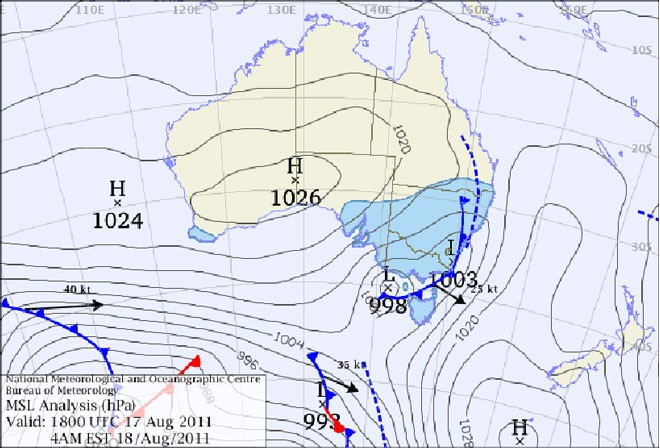
Meridien Marinas Airlie Beach Race Week forecast day six: Nil Warnings current. Synoptic Discussion: A ridge of high pressure lies over the race area. A trough over eastern Queensland will move across central waters later today and into Friday morning.
Latest surface analysis
Observations: At 0600hr Hamilton Island was reporting the following conditions: Wind 250deg at 05kn gusting to 07kn, Temp 18C, Pressure 1017hPa). Light SW land breezes were observed at coastal mainland places.
Forecast Winds for Middle of Pioneer Bay (Read Discussion below):
1000:MD360 DR(330-030) MS05 SR00-08kn, probably light and variable or glassout?
1200:MD010 DR(350-030) MS05 SR00-08kn, could be light and variable or glassout?
1400:MD020 DR(010-040) MS08 SR03-11kn, could be light and variable?
1600:MD020 DR(360-040) MS08 SR04-12kn, could be 220-190deg at 8-12kn (ave)?
Key to wind forecast: First column is forecast mean wind direction in deg Magnetic (MD). It is the 10min average (mean) value at a height of 10m above the water leading up to the hour quoted. The second column is the directional range (DR) of the wind direction in deg Mag. This takes into account the natural oscillation of the wind and is a function of the atmospheric stability, etc. The third column is the mean speed (MS) in knots (kn) and is the average 10min value leading up to the hour quoted at a height of 10m above the water. The last column is the wind speed range (SR) in knots and is the lowest wind speed to highest wind speed in the 10min leading up to forecast hour.
Discussion: Forecast gradient wind is expected to be 360deg at around 10kn.This gradient should see a 330-040deg surface wind today- more left offshore (gradient wind) further offshore and more right closer inshore (sea breeze). In all a tricky day??!!
Note: Wind will be lighter in the lee of any landmass and a little stronger and more gusty between islands (in channels and passages) and around some headlands.
Natural wind oscillations today around 15 to 30 deg away from effects of topography, tending 30 to 50 deg closer to the effects of any land mass and in lighter wind regimes.
Other possibilities: Wind speed could increase this morning and this afternoon by about 5kn or so ahead of the trough?
Wind direction will be 220-190deg after 1600hr? (you all should be celebrating well by then?)
Weather: Dry. Maximum land temperature at Airlie Beach: about 25 degrees.
Wind Waves: 0.1 to 0.6metres, less in lee of land, more when wind wave opposes tidal current and further offshore depending on fetch and wind speed.
(Wave heights quoted are significant wave heights).
Tide at Shute Harbour: Low of 0.90m at 0658hr, High of 2.58m at 1316hr and Low of 1.24m at 1859hr.
Tidal Stream: A good flood this morning becoming a good ebb during this afternoon. Be very careful particularly in the passages, channels, close to islands, etc.
Remember: Tide floods to the south and ebbs to the north in the Whitsundays.
Sea Temperature: 20-21 degrees.
Meridien Marinas Airlie Beach Race Week
website
If you want to link to this article then please use this URL: www.sail-world.com/87420