Please select your home edition
Edition
PredictWind - Routing 728x90 TOP

Volvo Ocean Race - Day 2 Mapfre takes over lead 50nm from Rock

by Richard Gladwell/Sail-World.com on 13 Oct 2014
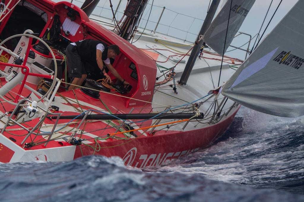
October 11, 2014. Following Dongfeng Race Team for their first Sunset at the Start of the Leg 1, from Alicante, Spain to Cape Town South Africa. Marc Bow / Volvo Ocean Race
With about 50nm to sail to reach the Straits of Gibraltar, Spain's Mapfre has taken over the front running and holds small lead of less than a mile over three other boats at 1840hrs UTC on Day 2.

Volvo Ocean Race reports:


Team Vestas Wind and Mapfre led the game until midday, reaching Cabo de Gata in first place. At around 1200 local time the boats entered the Alboran Sea and the wind dropped. Team Alimedica was reported to be leading, at 1730hrs, however in a position report just over an hour later Mapfre had taken the lead again.

The teams worked on their tactics in these tricky conditions, both along the coast and further offshore.

At 1530 UTC Mapfre and Dongfeng Race Team split from the fleet, taking an option away from the land, with a maximum lateral split of 5 nm. The others are sticking north for now, closer to the Andalusian coast.

The wind is expected to strengthen from the west as the boat leave the Alboran Sea. They should cross the Strait of Gibraltar tonight (around midnight). Whoever picks the Atlantic (trade) winds first will then gain some precious boat speed.


Routing gives up secret of lead change

Earlier in the day, the routing function of Predictwind suggested standing across to the other side of the Mediterrean and then approaching the Straits of Gibraltar form the African coast.

Consistent with the strategy expressed by the whole of the fleet that they did not want to be left behind in the Mediterranean, the fleet have largely ignored the routing advice and have stuck together in a more direct route.

The only breakout was Mapfre, who took a short hook out to sea, made the gain that the routing showed was there and when she came back had taken a small lead.

Normally navigators are not inclined to take some of the extreme courses indicated by routing software. however they do point to which is the favoured side of the direct line to the next waypoint, and usually shifting to that side will yield a gain over those who do not move away. Obviously the closer the fleet gets to the waypoint the options hut down to move away from the direct and shortest route.

From here for the final 50nm to Gibraltar, the recommended route is to stay on the direct line for Gibraltar, or to look at what the wind is doing inshore. Standing across to the other coast is not an option now, unless the fleet goes in that direction and Staying in Contact is the key for this stage..


PredictWind - Routing 728x90 BOTTOMPredictWind - Offshore App 728x90 BOTTOMPredictWind - GO! exec 728x90 BOTTOM

Related Articles

The Importance of Weather Forecasting
Understanding forecast weather conditions can be crucial to your survival PredictWind is a world-leading weather forecasting tool for boaters. Weather conditions such as storms, high winds, swells and currents can cause havoc for those on the water. Understanding forecast weather conditions can be crucial to your survival.
Posted on 1 Apr
Safe routing through the wind, waves, and current
Weather Routing does so much more than get you from A to B In seconds, know exactly what conditions are ahead, how comfortable the route will be, and how to safely and efficiently avoid bad weather, rough seas and shallow water with the world's most advanced routing algorithm.
Posted on 19 Mar
Predictwind announce Over the Horizon AIS
Predictwind have released an all new Over the Horizon AIS (OHA) feature on the DataHub Predictwind, the world leading weather information, forecasting and routing service have released an all new Over the Horizon AIS (OHA) feature on the DataHub. Users can view AIS data out to 300nm, directly on your chartplotter and nav apps.
Posted on 19 Feb
PredictCurrent: High-res tidal currents model
This groundbreaking solution empowers users to navigate local waters around the globe PredictWind, the leader in maritime weather technology, has announced the launch of PredictCurrent, the world's most comprehensive, high-resolution tidal currents model.
Posted on 5 Dec 2023
PredictWind unveils PredictCurrent
The world's most comprehensive, high-resolution tidal currents model PredictWind, the leader in maritime weather technology, announces the launch of PredictCurrent, the world's most comprehensive, high-resolution tidal currents model.
Posted on 1 Dec 2023
Predict Wind - Passage planning with PW tools
Having accurate and reliable weather information is paramount to maritime navigation In the world of maritime navigation, having accurate and reliable weather information is paramount to ensure the safety of voyages, whether coastal or transoceanic.
Posted on 2 Nov 2023
Free Atlantic Crossing webinar
Part one covered the basics of weather and communications Last week we kicked off our two part Webinar series covering everything you need to know for a successful Atlantic crossing.
Posted on 16 Oct 2023
Innovative Powerboat Weather Routing Tool
PredictWind's latest innovation transforms coastal and offshore passages PredictWind, the leading provider of marine weather forecasts and tools, proudly announces the launch of its pioneering weather routing feature specifically designed for Powerboats.
Posted on 28 Sep 2023
PredictWind: Perfect complement to your Starlink
Aiming to reshape the way mariners use their communications devices We at PredictWind are thrilled to announce our latest initiative that aims to reshape the way mariners use their communications devices.
Posted on 18 Sep 2023
More features with the DataHub 2.0 by PredictWind
Showcasing its commitment to providing mariners with more PredictWind, the world leader in marine forecasting, introduces the updated DataHub, showcasing its commitment to providing mariners with more. More features, more connectivity, increased safety.
Posted on 1 Sep 2023