Use These GPS 'Safety Circles' for Easy Navigation!
by John Jamieson on 18 Feb 2014
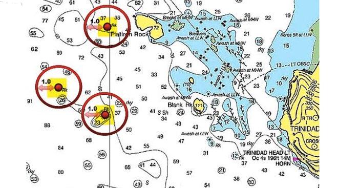
Separate circles Captain John Jamieson
http://www.skippertips.com
Imagine sailing along a coastline in good conditions. Suddenly fog, thicker than pea-soup or New England chowder cloaks your boat beneath a shroud of mist. Shoals pockmark the sailing route to starboard. Discover two ways to use your GPS to avoid grounding or damage to your hull, keel, rudder or propeller.
Set a waypoint into your GPS to mark nearby navigational dangers. Your nautical GPS will allow you to scribe an electronic 'circle' with a pre-determined radius. Enter this radius in tenths of a nautical mile. Touch the circle as you sail by and an alarm will sound. Make that circle radius large enough to give yourself time to sail toward safer water. Follow these easy sailing tips to discover two ways to do this:
Program Separate GPS Proximity Circles of Safety (image above):
1. Scan the sailing route to port, starboard and ahead. Look for rocks, wrecks, underwater obstructions (i.e. piles, stumps, dumping grounds, fish havens). Highlight each hazard on the chart or plotter screen. Use any color except red or yellow (both are difficult to see under red night lights). Now you will be able to spot the hazards at-a-glance in any weather, day or night.
2. Mark the center of each separate shoal or hazard with a waypoint. Label the waypoints with an alphanumeric character for easy identification and cross-reference with your GPS (i.e. H-1, H-2, H-3). Enter the latitude and longitude into your GPS. Measure again to make sure that no number has been transposed.
3. Determine a safe radius from each waypoint that will clear the hazard plus allow a margin of safety. Note in the illustration, we have determined a one nautical mile radius for each danger circle. You may find that some hazards require more or less. Allow a large margin of safety so that you have time to head up, bear away, tack or jibe as required to sail for safer water.
4. Enter this radius into your GPS 'distance to waypoint' function. It may have a different name, but will give you the option to enter a radius in nautical miles and tenths of a nautical mile. Your GPS alarm will trigger if you touch the edge of this virtual 'circle'. If your unit allows just one waypoint alarm at a time, choose that waypoint that represents the greatest threat to sailing safety. Reset the alarm to trigger at the next waypoint after you pass the first one.
5. Log your information. Whatever you have entered into the GPS, write down into the navigation log for future reference. Include waypoint name, description, latitude and longitude, and safety radius entered for each separate hazard. Now, if your GPS fails, you can enter the info into an alternate secondary GPS (or other device) in just a few minutes.
Program Single GPS Proximity Circles of Safety
1. Scan the sailing route to port, starboard and ahead as described earlier. Highlight rocks, wrecks, underwater obstructions (i.e. piles, stumps, dumping grounds, fish havens).
2. Estimate the approximate center of the cluster of dangers (see illustration). Give your waypoint an alpha-numeric name. Enter the latitude and longitude into your GPS. Measure again to make sure that no number was transposed or an error was made when measured.
Scribe a circle that encompasses all hazards. Adjust this circle so that you have a generous amount of room to take action. If your GPS alarms, you want plenty of time to head up, bear away, tack or jibe as needed to sail for deeper water. Enter this radius into your GPS and set the alarm.
3. Make a log entry into your ship's navigation log as described above. This will save you time and effort in case your GPS or plotter loses data. That way, you can transfer the information fast and easy to a backup plotter or GPS in just a matter of minutes.
~~~~~~~~~~~~~~~~~~~~
Use easy sailing navigation techniques like this to make sailing or cruising safer and easier. Keep your sailing crew safe and sound on the waters of the world--wherever you choose to sail!
John Jamieson (Captain John) with 25+ years of experience shows you the no-nonsense cruising skills you need for safer sailing worldwide. Visit his website at https://www.skippertips.com and sign up for his highly popular Sailing Tip of the Week. Discover how you can gain instant access to hundreds of sailing articles, videos, FREE e-Books and much more!
If you want to link to this article then please use this URL: www.sail-world.com/119390