Super Typhoon Soudelor biggest storm of 2015
by Sail-World Cruising on 4 Aug 2015
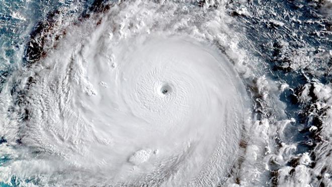
Super Typhoon Soudelor seen from Japan's Himawari-8 Satellite on Monday August 3, 2015 JMA / RAMMB / CIRA
Super Typhoon Soudelor has rapidly intensified in the Northwest Pacific, with sustained winds of 178 miles per hour (286km/hr), according to the Joint Typhoon Warning Center (JTWC). As of 4 p.m. ET, the storm had estimated wind gusts to a horrific 218 miles per hour,(351km/hr) or 190 knots.
This makes the typhoon the strongest tropical cyclone anywhere in the world so far in 2015. Remarkably, it is predicted to continue intensifying, potentially peaking at a 184-mile-per-hour monster, before slowly weakening as it approaches Taiwan and China by the end of the week. The storm is already stronger than Cyclone Pam was, which had maximum sustained winds of 165 miles per hour.(265km/hr)
Since Soudelor reached the equivalent of a category five intensity storm, with maximum sustained winds of 155 miles per hour (250km/hr) or greater, it has become the sixth such storm on Earth this year. The average number of these fierce storms is just 4.6 per year.
One factor that helps to account for the five category five storms (the strongest on the Saffir-Simpson Hurricane Intensity Scale) is a strengthening El Niño event in the tropical Pacific Ocean, which is boosting ocean temperatures across the area.
El Niño events tend to increase the number of storms in the eastern Pacific Ocean, while dampening the number of storms in the tropical Atlantic. Ocean temperatures north of the equator in the Western Pacific, a prime typhoon breeding ground, are also running nearly four degrees Fahrenheit above average for this time of year.
A
study published in May in the journal Nature Climate Change found that warming ocean temperatures worldwide, which is associated with manmade global warming, are leading to a decrease in the number of tropical cyclones, but an increase in the intensity of storms that do form.
Another recent
study found an increase in the number of storms in the Northwest Pacific, as sea surface temperatures warm in response to global warming.
Hurricanes and typhoons (which are the same type of storm, just referred to by different names) play a role in the climate system by transporting heat from the tropics to the poles. This heat-transport function may help explain why, with sea surface temperatures at an elevated level, there have been an unusually high number of powerful typhoons.
According to the JTWC, Super Typhoon Soudelor is likely to track steadily northwestward, reaching Taiwan on Aug. 7, and coastal China by Aug. 8. The Chinese city most likely to be threatened by the storm's landfall looks to be Fuzhou, which has a population of about two million. However, Shanghai, which has already been hit by one typhoon this season, lies within the cone of forecast uncertainty on the JTWC's storm track map.
Soudelor has already caused significant damage in Saipan, where it hit as an intensifying Category one to two storm. A state of disaster has been declared, and power is out across the island, which is home to about 50,000.
When the storm's eye passed directly over the small island, the unusually small eye caused an atmospheric pressure drop of 40 millibars in just one hour. Such rapid pressure plunges are extreme even for typhoons.
“I’ve seen multiple primary power poles down; I’ve seen cars flipped over the road; I’ve seen lots of torn roofs,” said John Hirsh, executive director of the American Red Cross in Saipa, according to Pacific Daily http://www.guampdn.com/story/news/2015/08/03/fema-cnmi-state-disaster-after-typhoon-soudelor-direct-hit/31042799/
[Sorry, this link had a problem]s
[Sorry, this link had a problem].
The track will also take the storm close to the southern Ryukyu Islands of Japan, some of which are the subject of territorial disputes between Japan and China.
If you want to link to this article then please use this URL: www.sail-world.com/137120