Predictwind - Images of Hurricane Matthew's trajectory - 0800GMT Oct 7
by Sail-World.com on 7 Oct 2016
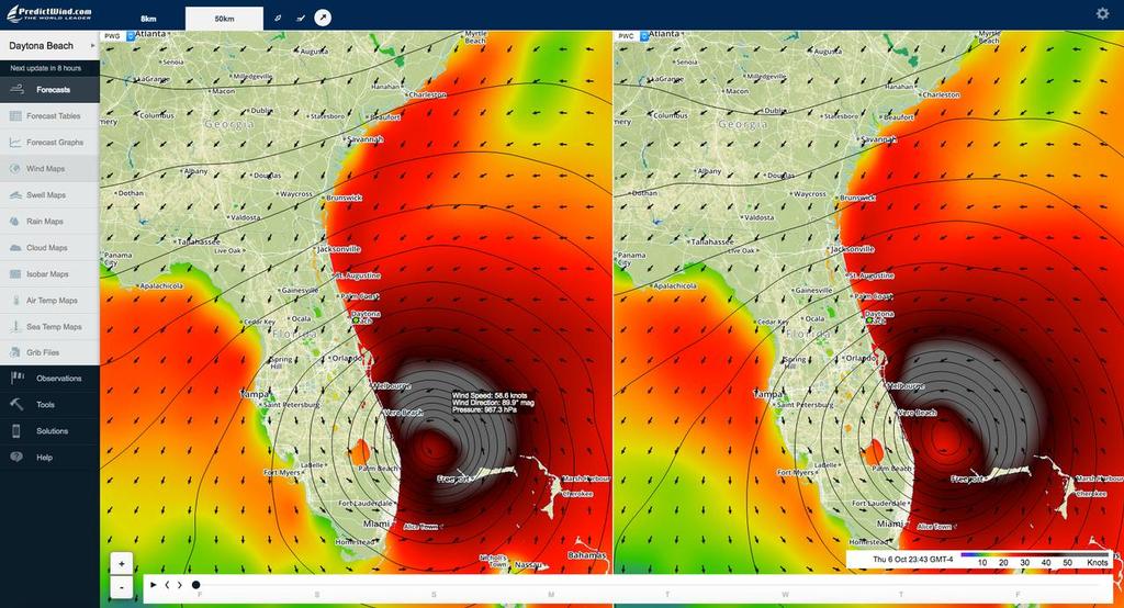
Hurricane Matthew off Daytona Beach - the text box shows a wind speed of 58kts, from 089 with a pressure of 987pa. PredictWind
Hurricane Matthew is now moving up the Florida coast, having bypassed Miami.
In these images from Predictwind's wind mapping facility we can see the path and shape of the of the hurricane as it moves past Daytona Beach moving along the US coast before coming to a stop around Jacksonville.
Using a feature of the wind map we can see in the latest projection that winds are still averaging just under 60kts (70mph/110kph) at the peak of the hurricane. Gusts would be expected to exceed that by 15-20% or more. Wind gusts in Haiti exceeded 150mph/130kts). The latest image was taken at at 0800hrs GMT on October 7.
The strongest winds are on the northern/seaward side of the hurricane.
The latest projections have it while winds do ease slightly as the hurricane moves along the US coast but when it hits Jacksonville where it is expected to stall winds average 60kts and gust to 72kts for a time. These figures are expected to be under-estimates.
The influence of what is now Hurricane Nicole, a second hurricane in the area, is a little uncertain. The latest projections show her stalling and losing intensity before joining the remnants of Hurricane Matthew and then heading up the East Coast to USA towards Nova Scotia. In Bermuda there is now just expected to be a period of strong winds on Wednesday Oct 12, rather than being touched up by Hurricane Nicole.
The path and intensity of the all storms in the area have significant changes daily.
This chart is a split screen showing the two feeds processed by Predictwind to take account of topography and other factors. These are wind charts only - other features in Predictwind show swell height (open water) and rainfall. Higher than normal tides are often a feature of deep depressions - which increases the damage caused by the large swells as they come ashore.
The Wind Charts below are in local time for Daytona Beach and Jacksonville. The show the wind as an average strength and gust. These are likely to be under estimates. The swell height is for open water in a breeze of that strength, it does not account for storm surge and tides - which may take the height up by 11ft from mean high tide.
Daytona Beach Wind chart
Jacksonville Wind Chart
About Predictwind:
Developed by former Olympian, Jon Bilger (470, 1992), PredictWind application was used by the Swiss team Alinghi to win the 2003 and 2007 America's Cups, and has become the leading wind system used by racing and recreational sailors around the world. It is available on a subscription basis and also with a free forecast option.
A mobile app for Android and iPhone is available and www.predictwind.com!PredictWind is available for download
Real time local wind observations have been added as further functionality.
You can check the weather anywhere in the world, and get a five-day forecast, plus a variety of other features and functions of www.predictwind.com!PredictWind. The app is synchronised with your PC so that your latest set of locations are always available without resetting each time you change a device
If you want to link to this article then please use this URL: www.sail-world.com/148762