Tropical cyclone Marcia set to hit Queensland coast possibly Cat 5
by Sail-World.com on 19 Feb 2015
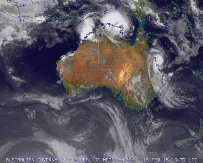
Infrared image courtesy of the Japan Meteorological Agency. Blue Marble surface image courtesy of NASA - Australian Government Bureau of Meteorology Australian Government Bureau of Meteorology
http://www.bom.gov.au/
Severe tropical cyclone Marcia, category 4, has moved slowly to the south southwest towards the Queensland coast. The cyclone is expected to continue moving in the same general direction overnight and make landfall between Mackay and Gladstone during Friday morning. Severe tropical Cyclone Marcia is still expected to reach the most intense category (category 5) before landfall but has at least temporarily stabilised at the stronger end of category 4 in the past few hours.
Details of Severe Tropical Cyclone Marcia at 9:00 pm EST:
Intensity: Category 4, sustained winds near the centre of 195 kilometres per hour with wind gusts to 270 kilometres per hour.
Location: within 9 kilometres of 20.8 degrees South 150.6 degrees East, estimated to be 145 kilometres east northeast of Mackay and 265 kilometres north of Yeppoon.
Movement: west southwest at 9 kilometres per hour.
A separate Severe Weather Warning is current to the south of Double Island Point and west to the Great Dividing Range.
Hazards:
The very destructive core of severe tropical cyclone Marcia, with gusts to 295 km/h, is expected to cross the coast between Mackay and Gladstone on Friday morning.
Destructive winds are expected to develop about coastal and island communities between Mackay and Burnett Heads tonight.
Gales are now occurring about coastal and island communities between Mackay and Double Island Point, and are expected to extend north to Bowen later this evening and inland to areas including Blackwater, Moura, Biloela, Monto, Mundubbera, Taroom, and Murgon overnight and Friday.
Abnormally high tides will be experienced today and Friday with water levels expected to rise above the highest tide of the year on the high tide. Note also that abnormally high tides are also likely on Friday evening's high tide in parts of the warning area even though the cyclone is likely to be over land and weaker by then.
Coastal residents between Mackay and Double Island Point are specifically warned of the dangerous storm tide as the cyclone crosses the coast, and in the following high tide well after landfall during Friday evening. The sea is likely to rise steadily up to a level well above the normal tide, with damaging waves and flooding of some low-lying areas close to the shoreline. People living in areas likely to be affected by this flooding should take measures to protect their property as much as possible and be prepared to follow instructions regarding evacuation of the area if advised to do so by the authorities.
Dangerous surf is expected about exposed beaches south of Sandy Cape.
Thunderstorms are expected to develop near the coast between St Lawrence and Hervey Bay ahead of tropical cyclone Marcia crossing the coast. These thunderstorms may produce localised areas of destructive wind gusts in excess of 125 km/hr about coastal and island communities.
Heavy rainfall will develop about coastal and island communities between Mackay and Double Island Point tonight, particularly over areas to the south of the system. A Flood Watch is current for the area.
Remarks
All ships in the area please send weather reports every three hours. Regular
weather observing ships use normal channels. Other ships please use either
email to marwxqld@bom.gov.au or fax to +61732200221 or satellite using SAC1241
through Land Earth Station Burum 312 [or 212 as appropriate] via Perth.
Recommended Action:
People between Bowen and Double Island Point should complete preparations quickly and be prepared to shelter in a safe place.
- Boats and outside property should be secured [using available daylight hours/before nightfall].
- For cyclone preparedness and safety advice, visit Queensland's Disaster Management Services website (www.disaster.qld.gov.au)
- For emergency assistance call the Queensland Fire and Emergency Service (QFES) on 132 500 (for assistance with storm damage, rising flood water, fallen trees on buildings or roof damage).
Next Advice:
The next advice will be issued by 10:00 pm EST Thursday 19 February.
This warning is also available through TV and Radio Broadcasts; the Bureau's website at www.bom.gov.au or call 1300 659 212. The Bureau and the State Emergency Service would appreciate this warning being broadcast regularly.
If you want to link to this article then please use this URL: www.sail-world.com/131695