Telcoinabox Airlie Beach Race Week 2012 day 5 weather
by Kenn Batt on 15 Aug 2012
Telcoinabox Airlie Beach Race Week 2012 Weather Kenn Batt
Telcoinabox Airlie Beach Race Week 2012 day 5 weather.
Nil Warnings current at time of writing for the race area.
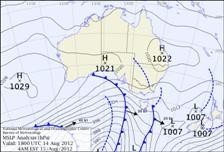
Synoptic Discussion:
A high currently centred over SE Queensland and moving slowly east to northeast and is extending a weakening ridge along the remainder of the Queensland coast.
Latest analysis
Observations:
At 0600hr Hamilton Island was reporting the following conditions:
Wind 170deg at 09kn (ave) gusting to 12kn, Temp 17C, Pressure 1022hPa).
Forecast Winds for Middle of Pioneer Bay (Read Discussion below)
1000:MD140 DR(170-130) MS12 SR06-16kn chance light and variable?
1200:MD120 DR(140-100) MS08 SR02-12kn chance of 'glassout'
1400:MD100 DR(120-080) MS10 SR06-14kn could be 030-060deg?
1600:MD080 DR(100-060) MS12 SR07-16kn could be 030-060deg?
1800:MD070 DR(090-050) MS10 SR05-15kn could be 030-060deg?
Whitsunday Passage and Molle Channel: Wind speeds maybe 2 to 3kn stronger in places than those above this morning, before easing to those values above by mid morning. Localised patchy winds developing from mid-morning. Winds could be a little gusty and erratic at times around some headlands and in more constrained locations.
Note : First column is mean wind direction in deg Magnetic (MD). It is the 10min average (mean) value at a height of 10m above the water leading up to the hour quoted. The second column is the directional range (DR) of the wind direction in deg Mag. This takes into account the natural oscillation of the wind and is a function of the atmospheric stability, etc. The third column is the mean speed (MS) in knots (kn) and is the average 10min value leading up to the hour quoted at a height of 10m above the water. The last column is the wind speed range (SR) in knots and is the lowest wind speed to highest wind speed in the 10min leading up to forecast hour.
Discussion
Today could be quite fickle and testy? You should see a light W-SW land breeze inshore early this morning, being replaced quickly by a light to moderate synoptic SE’er during the morning. The direction is then expected to trend left (or move toward the east and northeast) during the afternoon. The wind could become quite patchy at times especially in Pioneer Bay from around mid-morning? A mid to late morning 'glassout' to a sea breeze is likely in Pioneer Bay today?
Forecast chart for 1600hr today.
Note: Wind will be lighter in the lee of any landmass and stronger and more gusty between islands (in channels and passages) and around some headlands.
Natural oscillations today around 15 to 25 deg away from effects of topography, tending 30 to 50 deg closer to the effects of any land mass (including islands and headlands).
Weather
Cool at first. Chance of an early light shower especially around the Islands.
A fine and mostly sunny day.
Maximum land temperature at Airlie Beach: about 22 degrees.
Wind Waves:
0.5 to 1.2 metres. Less in lee of land, more when wind wave opposes tidal current and further offshore.
(Wave heights quoted are significant wave heights).
Tide at Shute Harbour: High of 1.72m at 0742hr, Low of 0.38m at 1347hr and High of 2.32m at 2015hr.
Tidal Stream: A good ebb from mid- morning to early afternoon, becoming slack before a strong flood later this afternoon/evening. Be very careful particularly in passages, channels, close to islands, etc.
Remember: Tidal currents generally flood to the south and ebb to the north in the Whitsundays (with a multitude of local effects and eddies. So be prepared!).
Sea Temperature: about 19-20 degrees.
Outlook
Thursday: Mostly sunny. SW-SE at 8-12kn (ave) tending E-NE during the afternoon. Good chance of a morning 'glassout' followed by a 8-12kn (ave) E-NE afternoon seabreeze.
If you want to link to this article then please use this URL: www.sail-world.com/100964