Fourth Blog from on board Perie Banou II
by Jon Sanders on 23 Nov 2016
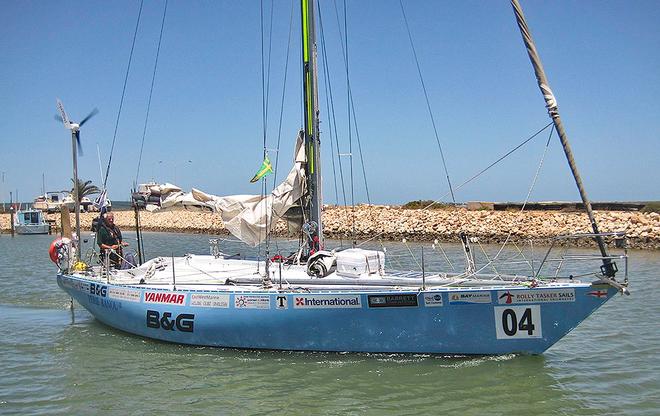
Jon Sanders departs Carnarvon in Western Australia Jim Macbeth
Hi all.
The B&G chartplotter tells me since leaving the pleasant mid Western Australian town of Carnarvon (by world standards, an isolated town), that I have sailed some 2559 NM and have 751nm to go to Le Port Reunion Island. French. Reunion is a Suburb (department) of Paris. Population 844,000.
Like the South Pacific, the southern Indian Ocean is my idea of a French lake. For example, going west and a little south of my own city of Perth and Fremantle in the State of Western Australia, there are the two Islands of St Paul and Amsterdam. 1900nm distant. French. 900nm SW of those Islands (in the roaring forties) is Kerguelen. Much fog and mist. French. 780nm NW of Kerguelen are the Iles Crozet. French.
Now 1500nm north of the Crozets at 21 degrees S (tropical unless one is in the mountains) Isle de La Reunion ( I am going there, just now, so I am). French. 780nm north west of Reunion, (crossing over the northern part of Madagascar) is Mayotte. You guessed it. French. From Mayotte going south in the Mozambique Channel are two Garrison held Islands in Juan de Nova and Isla Europa. French.
Meantime, I bought a nice coffee mug in Woolworths at Carnarvon. Yet now I can't find it. I have looked everywhere. I could not have hidden it, or I would know where it is. That aside, years back, in a Bunnings Hardware store I bought a stout bucket. Still got it. Tied to the bucket is a lanyard. It is normal for me to cast the bucket into the sea and fetch water. It's salty. I use the water to wash spoons, forks, plates etc. I then cast the dirty dishwater back into the sea.
I still cannot find my coffee mug. (Ed. Think we know where it is now….)
Previously mentioned, I read ‘Carpet of Silver’, by historian and geologist Phillip Playford. The story, 300 years and more back of the Dutch East India (VOC) ship ‘Zuytdorp’. She crashed into the ‘Zuytdorp Cliffs’. This was a book given to me by David Bowe. There is evidence that some survivors got ashore?
This very last October 2016 a yacht race and rally was held to celebrate the first ‘known’ European landing on Australian soil at Dirk Hartog Island by Dirk Hartog and his crew in 1616. The VOC sailing ship was ‘Eendracht’. The recent race and rally ended at the remote town of Denham in Shark Bay. Not so far from the elongated Dirk Hartog Island. It is part of Shark Bay.
So recently I set sail from Denham Shark Bay on Wednesday 26 October 2016 for the short run to Carnarvon (northern Shark Bay) for supplies and to clear Border Force. So it can be said I started SOLO from Shark Bay on my 10th circumnavigation. (I may not always be solo)!
I have the honour of two special books on board. ‘Carpet of Silver’ by Phillip Playford and the 415-page, ‘Shark Bay Through Four Centuries 1616 to 2000’ by Hugh Edwards. Reading it now. Very good. It would be nice for me on the completion of this voyage to present these two books to Hugh and Phillip or their families.
All going well, these excellent books will have been carried on the small sailing vessel, Perie Banou II’, around the world.
The late and former Premier of Western Australia, Sir Charles Court, had a historic hero in William Dampier. Englishman. 300 years back Dampier was the first to chart much of Shark Bay. It is a complicated bay. Dampier had a colourful background: privateer, scientist, explorer, botany. It was William Dampier that named ‘Shark Bay’. He is my hero too.
Last Monday night at 1030pm, 25kts east trade wind arrived in the dark of the night. The servo paddle, which is attached to my Airies Wind Vane self-steering gear (hangs below), broke away. The bolt went. The boat’s steering went ‘Berko’. Rough as bags. Bummer. I have two spare paddles or blades and it took me two hours to replace it.
After that made a cup of coffee (no mug) with piping hot milk (powdered) and Maccona freeze dried coffee - Dutch. No, not Nescafe, that's Swiss. (They have too many mountains).
Regards to all,
Jon
Notes from Robin Morritt
Perie Banou II is moving right along… Jon must be getting the hang of all the fancy computer hardware and software on board. He has been busy tapping out another blog that arrived on Tuesday 22nd November 2016.
A quick check of his position reveals he is at approximately latitude 22º 05’ S and longitude 70º 45’ E. In this area the oceanic crust is associated with three separate tectonic plates moving apart from each other as new ocean floor is formed. The injection of basaltic dykes into the spreading ridges produces the new oceanic crust.
The three tectonic plates are the Indo-Australian Plate (including India), the African Plate and the Antarctic Plate. The junction of these three plates is referred to as the “Indian Ocean Triple Junction”. If new ocean floor is injected evenly into each of the triple-junction spreading ridges then the angle between each arm would be 120º. The rate of new oceanic crust being produced varies, by centimetres per year, so these angles can vary accordingly.
Unique and extensive seafloor topography for Jon to navigate – liner ridges produced at the site of injection of this new oceanic crust. These active spreading ridges can be found dividing the major oceanic regions of the planet. They also enter smaller seas where new oceanic sea floor is being formed today. Think Red Sea, the Gulf of California… Sometimes this process can stop but evidence of the process remains. In Australia, think Spencer Gulf.
Jon has apparently lost his coffee mug and spoon? No problem – a saucepan would suffice. If these items went overboard right at the Indian Ocean Triple Junction they would have slowly settled to the sea floor a few kilometres below PBII’s track. Assuming they were not dissolved by an active, hot and acidic, mid-ocean-ridge fissure they would settle into a thin layer of anoxic pelagic ooze on the sea floor. Depending on which of the three tectonic plates Jon’s mug and spoon settle their future journeys could be markedly different.
Consider Jon’s coffee mug settling onto the Antarctic Plate and his spoon settling onto the Indo-Australian Plate. For starters, and within 12 months, yes 12 months, they could have moved apart (currents not withstanding) by 6 centimetres or more. The mug moving off towards Antarctica and the spoon towards Sumatra.
Given sufficient (geological) time the spoon could end up being subducted deep under Sumatra. By then of course, the spoon would have been inundated by huge volumes of carbonate from fringing coral reefs off Sumatra. Eventually ejected through a volcanic edifice such as Toba, or any of the other 170-plus active volcanoes in Indonesia, the spoon would be expelled with vast quantities of carbon dioxide - a by-product of the carbonate.
The last time Toba erupted was 74,000 years ago. It was a major earth event. That said, it is likely Jon’s mug (and spoon) will re-surface within short order from onboard PBII…
Having been on a possible boondoggle we should refocus on the significance of Jon’s current position and on ways to better understand its geological and global significance. To do so we need to go on another short excursion - this time to current remote sensing technologies and to the breath-taking information at our finger-tips.
Sensor technology has evolved at a similar pace to computer technology. This has enabled us, for example, to go to Google Earth and have a close look at imagery from anywhere on planet earth utilising data from the visible part of the electromagnetic spectrum - 0.4 to 0.8 micrometer wavelength; the blue + green + red light = white light. Go to Google Earth and search the Toba volcano. You will see an elliptical Lake Toba and its central volcanic cone - a dormant super volcano. We can, with different sensors, examine other wavelengths too… for example, ultravioletet and infrared. The 'visible' portion of the incident electromagnetic radiation (energy) from our sun is but a tiny fraction of the electromagnetic radiation reaching our planet earth.
Some sensors include incredibly accurate timing devices too. The GPS in your vehicle relies on geostationary satellite arrays and very accurate timing hardware to provide global positioning information.
So what has this got to do with Jon currently sailing PBII across the Indian Ocean? Well… It turns out the sea-surface mimics the seafloor in intricate topographic detail. All to do with minute gravity variations within sea-floor topography affecting the sea-surface topography.
What? Yes, indeed. If a satellite sensor can very accurately measure the global sea surface then it would be a proxy for the seafloor topography!
Enter satellite RADAR altimeters…
Explore the USA National Oceanic and Atmospheric Administration (NOAA) site and review “Exploring the ocean basins with satellite altimeter data” by David T. Sandwell - Scripps Institution of Oceanography and Walter H. F. Smith - Geosciences Laboratory, NOAA, here
In 2010 the European Space Agency launched CryoSat-2, a research satellite that went into service in 2011. The RADAR altimeter sensors on this satellite are specifically designed to scan the polar ice caps and enable quantification of ice volumes and changes to those volumes over time. Sensor coverage does, however, include the entire planet.
The Alfred Wegener Institute for Polar and Marine Research located in Bremerhaven Germany, is also involved in this project. What a coincidence! It is hard to imagine how Alfred Wegener would have responded to the data streaming from CryoSat-2. Onboard, highly accurate RADAR altimeters continuously map sea surface topography, enabling scientists to produce sea-floor topographic maps. Direct evidence of geological features postulated in the theory of continental drift able to be observed in these maps.
Refer to the European Space Agency CryoSat-2 site for general information here
CryoSat-2 data and analysis is presented in a 2014 paper titled: “New global marine gravity model from CryoSat-2 and Jason-1 reveals buried tectonic structure” by David T. Sandwell,*, R.Dietmar Müller, Walter H. F. Smith, Emmanuel Garcia and Richard Francis. Elements of their work are presented in a Scripps Institution of Oceanography, San Diego USA video titled 'Draining the Ocean Basins with CryoSat-2' on video here
The video is a ‘fly-around’ the planet tracing key mid-ocean spreading ridges and associated features; referred to in the video as the ‘global mid-ocean system’. The journey starts (1:48) in the North Atlantic and then heads south and between Cape of Good Hope and Antarctica, up into the mid-Indian Ocean where the Indian Ocean Triple Junction is discussed (3:20).
The journey then continues eastward between Australia and Antarctica and up into the Pacific Ocean. It ends in California along the San Andreas Fault system. Note that the continental areas are a uniform grey colour. All the topography shown is of the ocean floor. A red line marks the spreading ridges - referred to as ‘spreading boundaries’.
The parallel ‘lines’ that trail away from the spreading ridges are transform faults. The commentator refers to areas near the coast and covered in sediments. It would include continental shelf – crust part of the continents and not oceanic crust. These areas show less topographic detail.
The commentator refers to ‘match points’ (2:20). These are sites where the continents were originally together, part of a bigger single landmass or continental crust, prior to initial rifting and the formation of new oceanic crust: The commentator also refers to ‘new discoveries’ (2:36) in areas under sedimentary cover. These discoveries are of oil and gas within tectonically ‘passive’ continental margins. Similar ‘passive’ continental margins host the offshore oil and gas being exploited off Western Australia. An extensive passive margin also makes up the southern boundary of the Australian landmass…
Jon is closing on Reunion. We could calculate approximately how much his destination, Le Port, Réunion has moved away from Carnarvon since he departed. Nah! It would not be significant, being measured in millimetres. A different story if the calculation was made in a few million years.
For Jon and Perie Banou II: 'I was born in the breezes, and I had studied the sea as perhaps few men have studied it, neglecting all else.' - Joshua Slocum
If you want to link to this article then please use this URL: www.sail-world.com/149861