Forecast Meridien Marinas Airlie Beach Race Week Day 5
by Kenn Batt on 17 Aug 2011
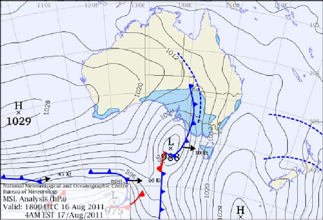
Meridien Marinas Airlie Beach Race Week day 5 forecast SW
Meridien Marinas Airlie Beach Race Week day five forecast: Nil Warnings current. Synoptic Discussion: A ridge of high pressure lies over the race area. Observations: At 0600hr Hamilton Island was reporting the following conditions: Wind 180deg at 11kn gusting to 13kn, Temp 18C, Pressure 1017hPa).
Light SW land breezes were observed at coastal mainland places. Some weak shower cells were observed well offshore.
Forecast Winds for Middle of Pioneer Bay (Read Discussion below).
0800:MD170 DR(190-150) MS08 SR04-12kn, could be light and variable or glassout?
1000:MD140 DR(160-120) MS10 SR06-15kn, could be light and variable or glassout?
1200:MD130 DR(150-110) MS12 SR08-16kn, could be 090-050deg?
1400:MD120 DR(140-100) MS12 SR08-17kn, could be 090-050deg?
1600:MD100 DR(120-090) MS12 SR08-17kn, could be 080-040deg?
1800:MD090 DR(110-070) MS12 SR07-16kn, could be 060-040deg?
Whitsunday Passage and Molle Channel: Wind speeds maybe two to three knots stronger at times than those above particularly around some headlands and in more constrained locations. Wind direction could be 10-30deg more left than above at times.
Further offshore: 130-100deg at 8-14kn (ave)
Key to wind forecast: First column is forecast mean wind direction in deg Magnetic (MD). It is the 10min average (mean) value at a height of 10m above the water leading up to the hour quoted. The second column is the directional range (DR) of the wind direction in deg Mag. This takes into account the natural oscillation of the wind and is a function of the atmospheric stability, etc. The third column is the mean speed (MS) in knots (kn) and is the average 10min value leading up to the hour quoted at a height of 10m above the water. The last column is the wind speed range (SR) in knots and is the lowest wind speed to highest wind speed in the 10min leading up to forecast hour.
Discussion: A ridge of high pressure currently lies over the Qld coast. Forecast gradient wind is expected to be 060deg at around 10kn.
This gradient should see a SE’ly into the area which is expected to trend left during the afternoon. It appears that we are now entering a lighter wind phase?
The big questions today are (hopefully answered in forecast above??):
1. How far left will the surface direction get?
2. How quickly will the direction turn left?
3. How strong will the winds be?
4. Will the wind drop out this morning and a light sea breeze develop?
Note: Wind will be lighter in the lee of any landmass and stronger and more gusty between islands (in channels and passages) and around some headlands.
Natural wind oscillations today around 15 to 20 deg away from effects of topography, tending 30 to 50 deg closer to the effects of any land mass and in lighter wind regimes. Shower celsl could cause short period gusty and erratic winds.
Other possibilities: 40% chance that wind drops out this morning and a 5-12kn E-NE sea breeze develops late morning/early afternoon??
Weather: Some cloud around today with the chance of isolated shower activity, chiefly morning and evening.
Maximum land temperature at Airlie Beach: about 23 degrees.
Wind Waves: 0.4 to 1.5metres, less in lee of land, more when wind wave opposes tidal current and further offshore depending on fetch. (Wave heights quoted are significant wave heights).
Tide at Shute Harbour: Low of 0.81m at 0628hr, High of 2.66m at 1238hr and Low of 1.02m at 1819hr.
Tidal Stream: A good flood this morning becoming a good ebb during this afternoon. Be very careful particularly in the passages, channels, close to islands, etc.
Remember: Tide floods to the south and ebbs to the north in the Whitsundays.
Sea Temperature: 20-21 degrees.
Outlook: Thursday: Glassout to weak seabreeze??
Meridien Marinas Airlie Beach Race Week
website
If you want to link to this article then please use this URL: www.sail-world.com/87383