Forecast Audi Hamilton Island Race Week Day 3 - Heavy Weather!!!
by Kenn Batt on 22 Aug 2011
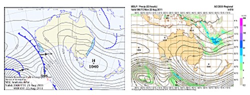
Forecast Audi Hamilton Island Race Week Day 3: Latest surface chart(left) and Forecast chart for 4pm today (right) SW
Audi Hamilton Island Race Week day three forecast: Great care required today. Warnings: A Strong Wind Warning is current.
Synoptic Discussion: A large high pressure system with a central pressure of 1040 hPa situated east of Tasmania, is moving slowly eastward. A broad trough of low pressure lies further to the east.
Observations: At 0600hr the surface wind at Hamilton Island was 150 deg at 24kn, gusting 28kn (temp 19C, pressure 1020hPa) indicative of the synoptic wind. At Hardy Reef (further offshore at 19.7S 149.2E) the wind was unavailable. At Creal Reef (20.53S 150.38E) the wind was SSE at 24kn.
Isolated showers were observed on weather radar.
Forecast Winds for Surprise Rock (Read Discussion below)
1000:MeanDir:150d DirRange:170-130d MeanSp:26kn Gust:36kn
1300:MeanDir:140d DirRange:160-120d MeanSp:26kn Gust:36kn
1600:MeanDir:140d DirRange:160-120d MeanSp:26kn Gust:36kn
1900:MeanDir:140d DirRange:160-120d MeanSp:26kn Gust:36kn
NOTE: Heavy showers and thunderstorms can produce short period squalls (up to 42kn) and short period wind shifts up to 180deg from the mean.
Key: MeanDir: Mean wind direction Degrees True, DirRange: Wind direction range Deg T , MeanSp: mean wind speed in Knots, Gust: Maximum wind speed possible in the 10secs leading up to the hour in Knots.
Discussion: Blowing dogs off chains today!
The big question marks today are:
1. How far left the wind direction? I’m thinking 120deg max left.
2. What will the average wind speeds be during the day and what will the maximum gusts reach? Average speeds 25-28kn with gusts to 35-37kn, stronger at times in any heavy shower or thunderstorm. There is a good chance that average speeds may be closer to 30kn at times and gusts a little stronger than forecast above?
Wind may be 2-5kn stronger at times than above in Dent/Fitzallen/Whitsunday Passages due to channeling/funnelling?
Wind may also be channeled/funnelled and hence locally stronger between islands and out of some bays. Wind may be lighter and more variable in the lee of any land mass.
Natural oscillations: around 15 to 20 deg away from the effects of the land, up to 180deg over short time periods with any shower or thunderstorm.
Weather: Cloudy at times with a few showers. Slight chance of a thunderstorm.
Maximum land temperature at Hamilton Island: 22 degrees.
Wind Waves: 1.5 to 2.7metres, less in lee of land, more in open water and when wind wave opposes tidal current.
(Wave heights quoted are Significant wave heights).
Current: A good flood for racing today. Be extremely careful in channels, etc.
Remember: Tide floods to the south and ebbs to the north in the Whitsundays but there can be huge localized variations.
Tide at Shute Harbour: Low 1.15m at 1056hr, High 2.71m at 1802hr
Sea Temperature: about 22 degrees.
Outlook. Tuesday: Cloudy with showers. Chance of a thunderstorm. SE winds at 25-30kn (ave), stronger further offshore.
Audi Hamilton Island Race Week
website
If you want to link to this article then please use this URL: www.sail-world.com/87545