Cyclone Ita predicted to reach Category 4 off Far North Queensland
by Sail-world.com on 9 Apr 2014
Australian Government Bureau of Meteorology
http://www.bom.gov.au/


Far North Queensland is bracing itself for what is expected to be the most severe cyclone since Yasi devastated homes and holiday resorts in 2011.
The weather bureau has warned that Tropical Cyclone Ita could strengthen to a category four system before crossing the coast around Friday evening.
The bureau says the cyclone, which was about 710 kilometres north-east of Cooktown at 7:30pm on Wednesday, is expected to bring very destructive winds when it makes landfall.
The system had picked up speed and was now moving west toward the Queensland coast at about 10 kilometres per hour.
A cyclone watch has been issued for Cape York communities between Port Douglas and Cape Grenville, north of Cairns.
If it continues on its current path, the bureau expects it to steer clear of populated areas.
But forecaster Michael Knepp told the ABC that ' if it tracks down the coast 'a few major populated areas are going to be affected.'
'This is the most intense tropical storm since Yasi, so we're always going to get a little bit tense about this,' he said.
Torrential rain and destructive winds of up to 280 kilometres per hour are expected.
Sea levels are expected to rise significantly above the normal tide between Cape Grenville and Cairns, and heavy downpours may lead to flooding and flash flooding in the Peninsula and Tablelands districts as early as Thursday.
The Great Barrier Reef resort of Lizard Island has been evacuated as a precaution and will be closed until Sunday.
State Emergency Services says communities including Port Douglas and Cooktown could be in for a rough time, but locals know what to expect.
'I think there's great response from the communities directly in the path, especially Lockhard River. They've made a lot of arrangements, through to Coen and Cooktown,' spokesman Wayne Coutts said.
Emergency Services Minister Jack Demspey says authorities will 'plan for the worst and hope for the best.'
'The logistics and the manpower have already gone into those places to assist the community,' he added.
As Tropical Cyclone Ita approaches the Queensland coast, find out more about cyclones and how they cause so much damage.
The town of Coen, north of Cairns, has run out of diesel, but Cook Shire Mayor Peter Scott says there is enough to run the local generator and supply emergency vehicles.
'Think very seriously about going north with the cyclone coming in,' he said.
Cairns Mayor Bob Manning says disaster services are preparing in case Cyclone Ita tracks further south and hits the city.
'I remember with Yasi just before we went to bed that night the reports were showing it coming pretty much at Cairns,' he said.
'I checked a few hours later and it was starting to turn down the coast a bit - you really don't know.'
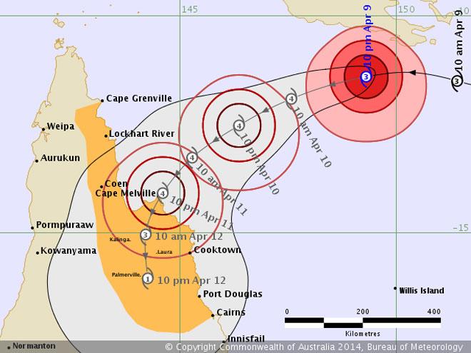
BOM Tropical Forecast Track Map Details
Remarks:
Severe Tropical Cyclone Ita, Category 3, is expected to continue moving in a general westwards direction towards the far north Queensland coast, while intensifying. Gales extend 220 kilometres out from the centre and may develop between Coen and Cooktown late Thursday and develop elsewhere between Cape Grenville and Cairns during Friday.
Severe Tropical Cyclone Ita poses a significant threat to communities along the far north Queensland coast and at this stage it is expected to approach the coast between Lockhart River and Cape Flattery and make landfall late Friday as a Severe Category 4 Tropical Cyclone with very destructive winds near the core and gales extending some distance from the landfall location.
The sea may rise steadily up to a level which will be significantly above the normal tide between Cape Grenville and Cairns close to landfall on Friday, with damaging waves, strong currents and flooding of low-lying areas possible. People living in low lying areas that may be affected by this flooding should take measures to protect their property as much as possible and be prepared to follow instructions regarding evacuation of the area if advised to do so by the authorities.
Very heavy rain, which may lead to flash flooding, is expected to develop about the Peninsula and northern parts of the North Tropical Coast and Tablelands districts on Thursday and persist into Friday.
People between Cape Grenville and Cairns should consider what action they will need to take if the cyclone threat increases and listen to the next advice at 5am EST Thursday.
- Information is available from your local government
- For cyclone preparedness and safety advice, visit Queensland's Disaster Management Services website (www.disaster.qld.gov.au)
- For emergency assistance call the Queensland State Emergency Service (SES) on 132 500 (for assistance with storm damage, rising flood water, fallen trees on buildings or roof damage).
Name: Severe Tropical Cyclone Ita
Details:
|
|
Time (EST)
|
Intensity Category
|
Latitude
(decimal deg.)
|
Longitude
(decimal deg.)
|
Estimated Position
Accuracy (km)
|
|
0hr
|
10 pm April 9
|
3
|
11.4S
|
149.3E
|
20
|
|
+6hr
|
4 am April 10
|
4
|
11.6S
|
148.4E
|
45
|
|
+12hr
|
10 am April 10
|
4
|
11.9S
|
147.6E
|
65
|
|
+18hr
|
4 pm April 10
|
4
|
12.2S
|
146.9E
|
90
|
|
+24hr
|
10 pm April 10
|
4
|
12.5S
|
146.4E
|
115
|
|
+36hr
|
10 am April 11
|
4
|
13.3S
|
145.3E
|
150
|
|
+48hr
|
10 pm April 11
|
4
|
14.1S
|
144.6E
|
185
|
|
+60hr
|
10 am April 12
|
3
|
15.0S
|
144.2E
|
220
|
|
+72hr
|
10 pm April 12
|
1
|
16.1S
|
144.3E
|
255
|
Tropical Cyclone information is also available in
MetEye.
The next Forecast Track Map will be issued by 5:00 am EST Thursday.
IDQ20023
Australian Government Bureau of Meteorology
Queensland
Tropical Cyclone Warning Centre
Media: The Standard Emergency Warning Signal should not be used with this
warning.
Priority
Tropical Cyclone Advice Number 4
Issued at 10:47 pm EST on Wednesday 9 April 2014
A Cyclone Watch remains current for coastal areas from Cape Grenville to Cairns, extending up to 200 kilometres inland to areas including Kalinga, Laura, and Palmerville.
At 10:00 pm EST Severe Tropical Cyclone Ita, Category 3, was estimated to be 670 kilometres east northeast of Lockhart River and 630 kilometres northeast of Cooktown, and moving west at 19 kilometres per hour.
Severe Tropical Cyclone Ita, Category 3, is expected to continue moving in a general westwards direction towards the far north Queensland coast, while intensifying. Gales extend 220 kilometres out from the centre and may develop between Coen and Cooktown late Thursday and develop elsewhere between Cape Grenville and Cairns during Friday.
Severe Tropical Cyclone Ita poses a significant threat to communities along the far north Queensland coast and at this stage it is expected to approach the coast between Lockhart River and Cape Flattery and make landfall late Friday as a severe Category 4 tropical cyclone with very destructive winds near the core and gales extending some distance from the landfall location.
The sea may rise steadily up to a level which will be significantly above the normal tide between Cape Grenville and Cairns close to landfall on Friday, with damaging waves, strong currents and flooding of low-lying areas possible.
People living in low lying areas that may be affected by this flooding should take measures to protect their property as much as possible and be prepared to follow instructions regarding evacuation of the area if advised to do so by the authorities.
Very heavy rain, which may lead to flash flooding, is expected to develop about the Peninsula and northern parts of the North Tropical Coast and Tablelands districts on Thursday and persist into Friday.
People between Cape Grenville and Cairns should consider what action they will need to take if the cyclone threat increases and listen to the next advice at 5am EST Thursday.
- Information is available from your local government
- For cyclone preparedness and safety advice, visit Queensland's Disaster
Management Services website (www.disaster.qld.gov.au)
- For emergency assistance call the Queensland State Emergency Service (SES) on 132 500 (for assistance with storm damage, rising flood water, fallen trees on buildings or roof damage).
Details of Severe Tropical Cyclone Ita at 10:00 pm EST:
.Centre located near...... 11.4 degrees South 149.3 degrees East
.Location accuracy........ within 20 kilometres
.Recent movement.......... towards the west at 19 kilometres per hour
.Wind gusts near centre... 220 kilometres per hour
.Severity category........ 3
.Central pressure......... 962 hectoPascals
The next advice will be issued by 5:00 am EST Thursday 10 April.
This warning is also available through TV and Radio Broadcasts; the Bureau's
website at www.bom.gov.au or call 1300 659 212. The Bureau and the State
Emergency Service would appreciate this warning being broadcast regularly.
A map showing the track of the cyclone is available
here.
If you want to link to this article then please use this URL: www.sail-world.com/120959