America's Cup- Predictwind - Marginal conditions for Day 5
by Richard Gladwell on 15 Sep 2013
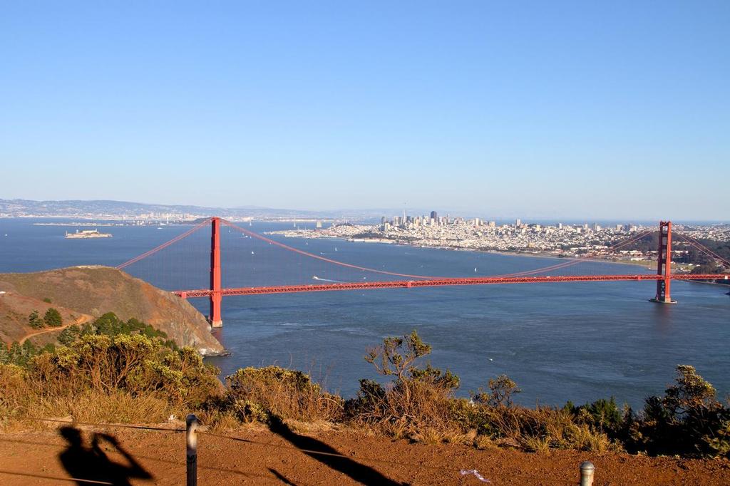
The America’s Cup Race Course, framed by the Golden Gate Bridge - today the wind blows from right to left, and the ebbing tide flows from left to right against the windflow. The blue sea that can be seen behind the City to the right, is not ocean but the greater expanse of the San Francisco Bay - which exits through the relatively narrow channel under the Bridge. Richard Gladwell
www.photosport.co.nz
Predictwind indicates that fresh winds winds will again prevail for Saturday, Races 8 and 9 of the 2013 America's Cup. The first race starts at 1.15pm on Saturday, local time with the second race scheduled for 1415hrs. Racing has concluded in the 18fter International.
Today we show a new feature of Predictwind - course routing optimised for wind and tide on the AC race course. See bottom of story for the course vatiations.
Officially the breeze is being forecast at 19-23kts. Today is the first race day which will be held in an ebbing (outgoing tide) which will see a wind against tide condition in the main channel of the course - building standing waves which will require a more seamanlike approach to mark rounding at Mark 1 and Mark 3 in particular. At the bottom of the course there is minimal tidal effect on the sea condition.
With the racing at its regular start time of 1315hrs the two feeds produced by Predictwind indicate that winds will be averaging around 22kts, with the breeze having been up all night at around 15kts. The key point is that on the graph image the two weather feeds produced by Predictwind are very close together for the ten hours leading into the race start suggesting the the certainty of the prognosis is high. There is only a small amount of breeze build before the start, although for Race 2, winds are predicted to be over the limit of 23 kts with the feeds showing 23-24kts.
Today there was a heavy fog over San Francisco, which lifted as the morning progressed. However the City remains overcast - which may restrict the inland heating which drives the Frisco 'Doctor'. When there is fog, the cold air on the sea gets angrily sucked in by the hotter inland systems, increasing the strength of the breeze. Unfortunately the fog is not easy to predict or measure and so it is a random factor in the forecast.
The above image shows the wind speed and direction at 1300hrs with breezes expected to be 22kts at the start of Race 8 - these are only average speeds and gusts will be higher, but not enough to exceed the wind limit. There is a little variation in the forecast indicating a higher degree of certainty as to the outcome.
The key feature of the forecast is close agreement between the two feeds as to the rate of build of the breeze, and around race start they are consistent in their projection.
A feature of the wind image map for both 1300 and 1400hrs (above and below) is the intensity of the breeze in the actual race area - driven by the surrounding topography, which is factored into the detailed 1km forecast option used to compile these predictions. Surrounding the race area, winds are significantly lighter in strength at both times. The wind source, to the west of Golden Gate Bridge is also less strong than the strength to the east of the landmark - again a function of the wind being sucked between the two high headlands on which the Bridge is constructed, before fanning out into San Francisco Bay and losing intensity.
A similar but reverse effect happens with the tide flowing from east to west, against the wind, and with the massive body of water which forms San Francisco Bay trying to exit under the Golden Gate Bridge - a little like a bath draining down a plughole - with the plughole being the entrance to the Bay under the Golden Gate Bridge.
The second image (above) shows a graphic representation of the wind build - confirming the numbers for the prognosis. If the breeze builds later than predicted, then the light winds soon one the left of the graph will extend through to the race start time.
The top image shows the wind speed and direction at 1400hrs with breezes expected to rise to 23-24kts at the start of Race 9 - these are only average speeds and gusts will be higher, probably exceeding the wind limit of 23kts.
The key feature of the forecast is agreement between the two feeds as to the rate of build of the breeze, and again around race start they are consistent in their projection.
The second image (above) shows a graphic representation of the wind build - confirming the numbers for the prognosis.
The third chart (below) shows the wind expectations for Saturday and Sunday. Typically the forecast for Sunday is revised upwards closer to the time of the race start. Note that sea conditions described in this chart are based on open water and are not descriptive of an enclosed harbour
The courses optimised by Predictwind for an AC72 show that the optimum course only has a small variation between the two races. The faint purple line shows the recommended course for Race 8 and the red dotted line shows the course recommended for Race 9. The mark positions used in this projection are only very approximate - and will vary on the course set for the day.
Two weather feeds are used by Predictwind, the key to the accuracy of the forecast lies with the graphs, as when the two lines for the two feeds are quite close together and following each other in the trend, then the likelihood of the forecast is high. If there is separation to any marked degree, then there still some issues to be resolved but usually 24 hours from the race they are well aligned.
The Predictwind model takes various weather feeds and then polishes these, part of this process is factoring in the effect of local topography on the breeze - well demonstrated by the image with the funneling of the breeze.
Developed by former Olympian, Jon Bilger (470, 1992), www.predictwind.com!PredictWind application was used by the Swiss team Alinghi to win the 2003 and 2007 America's Cups, and has become the leading wind system used by racing and recreational sailors around the world. It is available on a subscription basis and also with a free forecast option.
A mobile app for Android and iPhone is available and www.predictwind.com!PredictWind is probably the most used app on the Sail-World iPhone.
Real time local wind observations have been added as further functionality.
You can check the weather anywhere in the world, and get a five day forecast, plus a variety of other features and functions of www.predictwind.com!PredictWind. The app is synchronised with your PC, so that your latest set of locations are always available without resetting each time you change a device.
If you want to link to this article then please use this URL: www.sail-world.com/114477