Please select your home edition
Edition
PredictWind - Offshore App 728x90 TOP

Get better wave forecasts from PredictWind and ECMWF

by Predictwind on 12 Jul 2017
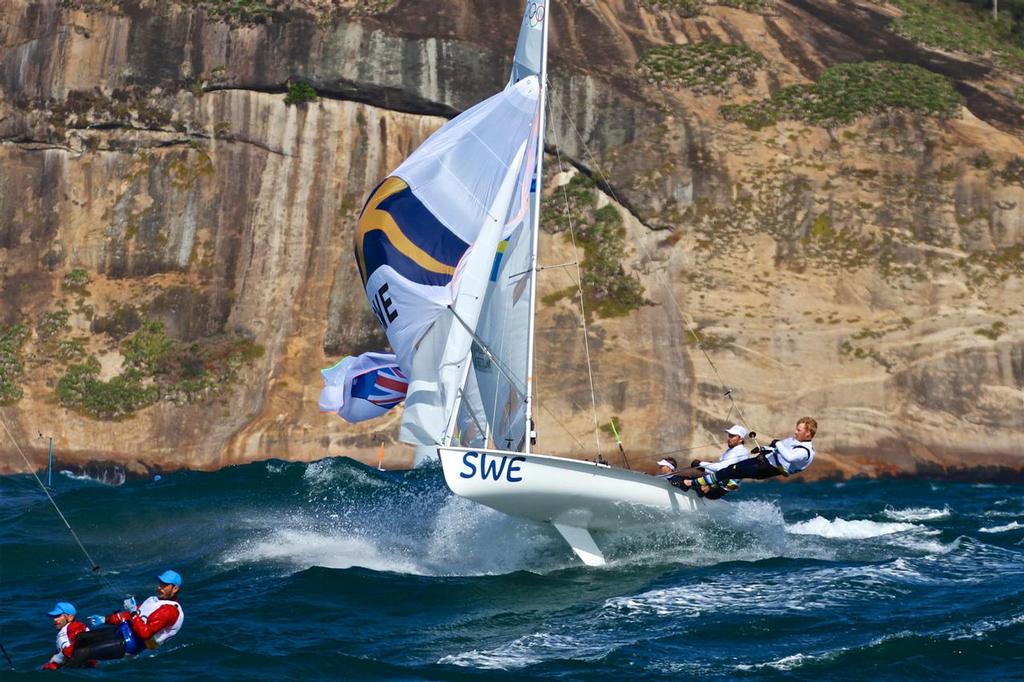
The Swedish mens crew launch in the 20-25kts winds and 3-4 metre Atlantic Ocean swells heading for the finish of Race 3 of the Mens 470, 2016 Olympics. With the Australian crew to leeward and the Greek crew ahead. A race management boat is visible with just its aerials showing. Richard Gladwell www.photosport.co.nz
PredictWind is well known for its world leading accurate wind forecasts, but did you know Predictwind also leads the way with accurate wave forecasts?

How are the wave forecasts produced?
The proprietary PredictWind PWG/PWE wind forecasts are used to drive the WaveWatch III wave model run by PredictWind to produce an accurate 50km resolution PWG/PWE wave forecast. In addition we have recently added the WAM model from ECMWF that is run at an incredible 14 km resolution globally, and currently rated the best wave model from any national weather centre.

What does the wave height represent?
The wave height is the mean wave height from trough to crest of the highest third of the waves, which is known as the 'significant wave height'. The significant wave height is generated from the primary swell and also the local wind wave. Also taken into account is the effect of ocean current.

What do the wave Maps show?
The colour gradients show the significant wave height for swell and wind waves, the black arrows show the primary wave direction, and the contours indicate the mean swell period in seconds. By moving your cursor over the map (or clicking in the iOS/Android App) you can see the wave height, period and direction.

What is the global coverage for wave forecasts?
We have full global ocean coverage with the PWG/PWE/WAM wave model. The WAM model from ECMWF has full global coverage, including the Great Lakes.

Do the PredictWind tools use this data?
Yes the PredictWind weather routing and departure planning tools use this data to optimise your route for comfort, and highlight any areas that could be dangerous in terms of waves.

What packages are this data available with?
The PWG/PWE wave models are available in the free package, whilst the WAM model from ECMWF is available on the Website/PredictWind App in the Standard Package. The WAM GRIB files are available in the Professional package.

To see more at click here
PredictWind - Offshore App 728x90 BOTTOMPredictWind - Wave Routing 728x90 BOTTOMPredictWind - GPS 728x90 BOTTOM

Related Articles

The Importance of Weather Forecasting
Understanding forecast weather conditions can be crucial to your survival PredictWind is a world-leading weather forecasting tool for boaters. Weather conditions such as storms, high winds, swells and currents can cause havoc for those on the water. Understanding forecast weather conditions can be crucial to your survival.
Posted on 1 Apr
Safe routing through the wind, waves, and current
Weather Routing does so much more than get you from A to B In seconds, know exactly what conditions are ahead, how comfortable the route will be, and how to safely and efficiently avoid bad weather, rough seas and shallow water with the world's most advanced routing algorithm.
Posted on 19 Mar
Predictwind announce Over the Horizon AIS
Predictwind have released an all new Over the Horizon AIS (OHA) feature on the DataHub Predictwind, the world leading weather information, forecasting and routing service have released an all new Over the Horizon AIS (OHA) feature on the DataHub. Users can view AIS data out to 300nm, directly on your chartplotter and nav apps.
Posted on 19 Feb
PredictCurrent: High-res tidal currents model
This groundbreaking solution empowers users to navigate local waters around the globe PredictWind, the leader in maritime weather technology, has announced the launch of PredictCurrent, the world's most comprehensive, high-resolution tidal currents model.
Posted on 5 Dec 2023
PredictWind unveils PredictCurrent
The world's most comprehensive, high-resolution tidal currents model PredictWind, the leader in maritime weather technology, announces the launch of PredictCurrent, the world's most comprehensive, high-resolution tidal currents model.
Posted on 1 Dec 2023
Predict Wind - Passage planning with PW tools
Having accurate and reliable weather information is paramount to maritime navigation In the world of maritime navigation, having accurate and reliable weather information is paramount to ensure the safety of voyages, whether coastal or transoceanic.
Posted on 2 Nov 2023
Free Atlantic Crossing webinar
Part one covered the basics of weather and communications Last week we kicked off our two part Webinar series covering everything you need to know for a successful Atlantic crossing.
Posted on 16 Oct 2023
Innovative Powerboat Weather Routing Tool
PredictWind's latest innovation transforms coastal and offshore passages PredictWind, the leading provider of marine weather forecasts and tools, proudly announces the launch of its pioneering weather routing feature specifically designed for Powerboats.
Posted on 28 Sep 2023
PredictWind: Perfect complement to your Starlink
Aiming to reshape the way mariners use their communications devices We at PredictWind are thrilled to announce our latest initiative that aims to reshape the way mariners use their communications devices.
Posted on 18 Sep 2023
More features with the DataHub 2.0 by PredictWind
Showcasing its commitment to providing mariners with more PredictWind, the world leader in marine forecasting, introduces the updated DataHub, showcasing its commitment to providing mariners with more. More features, more connectivity, increased safety.
Posted on 1 Sep 2023