Audi Hamilton Island Race Week - Daily weather forecast
by Kenn Batt on 24 Aug 2013
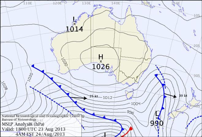
Surface chart 24th August - Audi Hamilton Island Race Week 2013 SW
Audi Hamilton Island Race Week - Daily Weather Forecast issued by Kenn Batt at 0615hr for Saturday 24th August 2013.
Nil Warnings current.
Synoptic Discussion:
A weak ridge of high pressure persists over the race area.
Observations:
At 0600hr the surface wind at Hamilton Island was 240 deg at 3kn, gusting 4kn (temp 18C, pressure 1020hPa). At Hardy Reef (further offshore at 19.7S 149.2E) the wind was 110deg at 4kn.
Forecast Winds for Surprise Rock (to E of Hamilton Island) (Read Discussion below)
0800:MD160 DR(180-140) MS05 SR00-08kn could be light and variable?
1000:MD140 DR(160-120) MS06 SR01-09kn could be light and variable?
1200:MD120 DR(140-100) MS07 SR03-10kn
1400:MD100 DR(120-080) MS09 SR05-13kn
1600:MD090 DR(110-070) MS10 SR06-14kn
1800:MD070 DR(100-060) MS11 SR07-15kn
Key: First column is mean wind direction in deg Magnetic (MD). It is the
10min average (mean) value at a height of 10m above the water leading up to the hour quoted. The second column is the directional range (DR) of the wind direction in deg Mag. This takes into account the natural oscillation of the wind and is a function of the atmospheric stability, etc. The third column is the mean speed (MS) in knots (kn) and is the average 10min value leading up to the hour quoted at a height of 10m above the water. The last column is the wind speed range (SR) in knots and is the lowest wind speed to highest wind speed in the 10min leading up to forecast hour.
Discussion
All the computer models that count are in pretty good agreement. i.e light!!
The forecast gradient wind is expected to be 120deg at 5-10kn.
The surface wind today is expected to commence as a light land breeze (230-210deg) shifting to 160-140deg and then trending left during the day under the influence of a weak sea breeze component.
The following questions still continue to plague us:
1. How far left? The weak sea breeze component should assist the left trend. For your racing period a max left of 060deg is possible.
2. How quickly will the direction trend left? I’m happy with forecast above however there is a 60% chance that a weak sea breeze develops via a 'glassout' . This situation would see from about 1200-1300hr an 080-040deg at 4-09kn develop?
3. How strong the winds? Pretty happy with the wind ranges above. There is a 70% chance that speeds are about 2kn stronger from about 1400hr?
Wind direction and speed is expected to be more variable than forecast above over parts of the race course (especially within the general Whitsunday Passage area) due to changing topographical profiles i.e. wind speed enhancement (+2 to 5kn) due to funneling out of bays, some speed enhancement and wind directional changes around headlands and in passages. Lighter and more variable winds in the lee of islands, etc
Natural wind direction oscillations: around 20 to 40 deg, more/less due to topographical influences.
Weather
Dry and sunny.
Maximum land temperature at Hamilton Island: 23 degrees. Proserpine: 26deg
Sea Temperature: about 22 degrees.
Wind Waves:
0.1 to 0.4 metres.
Heights less in lee of land and more when wind wave opposes tidal current.
(Wave heights quoted are Significant wave heights).
Tidal Current: A strong flood first up this morning followed by slack water and then a strong ebb developing this afternoon.
Be extremely careful in narrow channels, etc.
Remember: In general tidal currents flood to the south and ebb to the north in the Whitsundays. There are many localized variations however so be very vigilant.
Tide at Shute Harbour:
Low 0.50m at 0642hr, High of 3.01m at 1257hr, and Low 0.80m at 1850hr.
(know your time offsets for other locations around the race courses)
If you want to link to this article then please use this URL: www.sail-world.com/113576